THE IMAGINARY LINES-LATITUDE AND LONGITUDE
The latitude and longitude are the imaginary lines that help us in locating a relative position of a point on the earth’s surface in terms of angular distance, north and south of the equator from the centre of the earth.
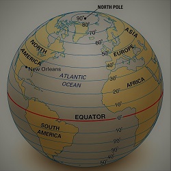
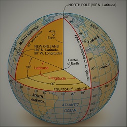
The latitudes are also called parallel, the circular lines that are running parallel to the equator. The equator, the longest latitude is located at 0° and it divides the earth into two equal halves i.e the northern hemisphere and the southern hemisphere. The latitude is the point of the angular distance that is measured 90° North-90° South of the equator. The line connecting all the points on the same latitude is called the line of latitude. All the lines of latitude are parallel to the equator. Therefore they are also known as the parallel. At the poles, the circle shrinks to a point. The latitudinal distance of 1° = 111 KM.
THE IMPORTANT LATITUDES AND LONGITUDE
| NAME OF THE CIRCLE | PASSING THROUGH COUNTRIES | WATER BODIES | GULF | STRAIT |
| THE ARCTIC CIRCLE / POLAR CIRCLE | NORWAY, SWEDEN, FINLAND, RUSSIA, ALASKA, CANADA, GREENLAND, ICELAND | ARCTIC AND ATLANTIC OCEAN | ||
| THE TROPIC OF CANCER | ALGERIA, NIGER, LIBYA, EGYPT, SAUDI ARABIA, UNITED ARAB EMIRATES, OMAN, INDIA, BANGLADESH, MYANMAR, CHINA, TAIWAN, MEXICO, BAHAMAS, WESTERN SAHARA, MAURITANIA, MALI, ALGERIA | RED SEA, INDIAN OCEAN, PHILIPPINE SEA, PACIFIC OCEAN, ATLANTIC OCEAN | GULF OF CALIFORNIA, GULF OF MEXICO | TAIWAN STRAIT |
| THE EQUATOR | SAO TOME AND PRINCIPE, GABON, REPUBLIC OF THE CONGO, DEMOCRATIC REPUBLIC OF THE CONGO, UGANDA, KENYA, SOMALIA, INDONESIA, ECUADOR, COLOMBIA, BRAZIL | ATLANTIC OCEAN, LAKE VICTORIA, INDIAN OCEAN, MOLUCCA SEA, HALMAHERA SEA, PACIFIC OCEAN, ATLANTIC OCEAN | GULF OF TOMINI | KARIMATA STRAIT, MAKASSAR STRAIT, |
| THE TROPIC OF CAPRICORN | NAMIBIA, BOTSWANA, SOUTH AFRICA, MOZAMBIQUE, MADAGASCAR, AUSTRALIA, CHILE, ARGENTINA, PARAGUAY, BRAZIL | ATLANTIC OCEAN, INDIAN OCEAN, PACIFIC OCEAN | ||
| THE ANTARCTIC CIRCLE/ POLAR CIRCLE | ANTARCTICA, BALLENY ISLANDS | SOUTHERN OCEAN | ||
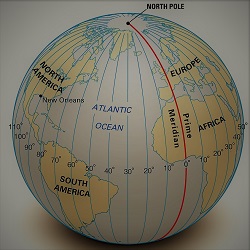
| THE PRIME MERIDIAN | FRANCE, UNITED KINGDOM, SPAIN, ALGERIA, MALI, BURKINA FASO, TOGO, GHANA, ANTARCTICA | ARCTIC OCEAN, EXCLUSIVE ECONOMIC ZONE OF GREENLAND, NORWAY, GREAT BRITAIN, GREENLAND SEA, NORWEGIAN SEA, NORTH SEA, ENGLISH CHANNEL, MEDITERRANEAN SEA, ATLANTIC OCEAN, SOUTHERN OCEAN |
The longitudes are also called Meridians or Semi-Circles. These imaginary lines run pole to pole (North-South Pole). The equator is a circle, therefore, it can be divided into 360 divisions. These divisions are called Zones. The semi-circle, unlike latitudes, the distance between two adjacent longitudes is 111.32 km and is more towards the equator and it decreases and it becomes zero at the poles where they get converge. Like equator, the meridian at zero degrees is called the Prime Meridian it runs north to south. In 1884 it was decided through an international agreement, that the longitude passing the Royal Observatory at Greenwich near London will be considered as zero degrees and be called the Prime Meridian. There are 180 longitudes on both sides of the prime meridian i.e total 360. The earth is geoid in shape, the linear distance is estimated to be about 25000 miles i.e for 1°each the distance is will be 69.4 miles (360*69.4= 24984 miles). Earth takes 4 minutes to move by
1° of longitude. The longitudes are used for calculating time in respect of Greenwich meantime.
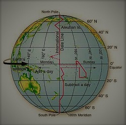
THE INTERNATIONAL DATELINE
The International Dateline in roughly corresponds to 180° East or West of the longitude which falls opposite to the prime meridian. The date changes by one day as the line is crossed. On crossing this line from East to West a day is added and vice versa a day is subtracted. A conference was held in Washington D.C in 1884, that led to the establishment of the international dateline. The line has no astronomical and physical importance. The line avoids continuous landmasses and is slightly bent at 75° North latitude towards the east to avoid the division of Siberia and Alaska. It bents again over Bering Strait. to maintain the continuity of the line the islands of Fiji and New Zealand the dateline is bent towards the east in the pacific ocean. For better trade with New Zealand and Australia, Samoa the islands in the south pacific has shifted on the west side of the international dateline.